

Dún Briste - ‘Broken Fort’
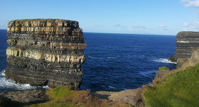
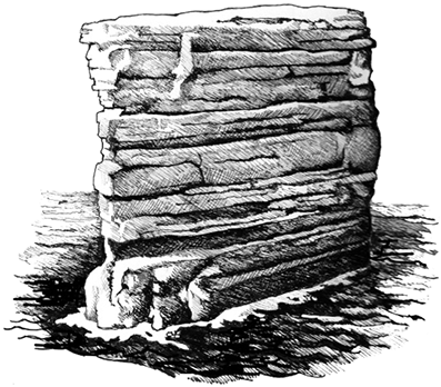
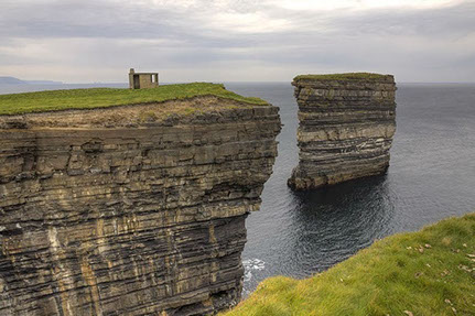
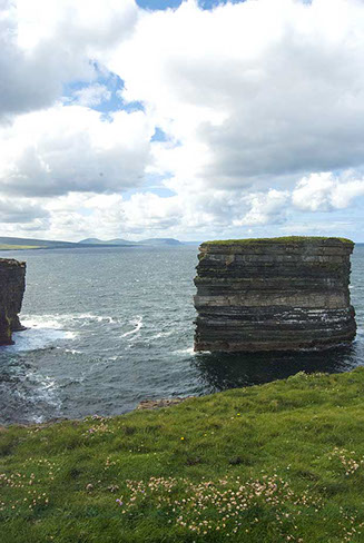
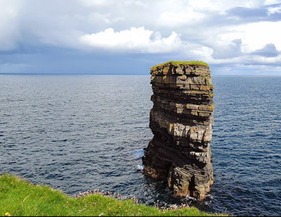
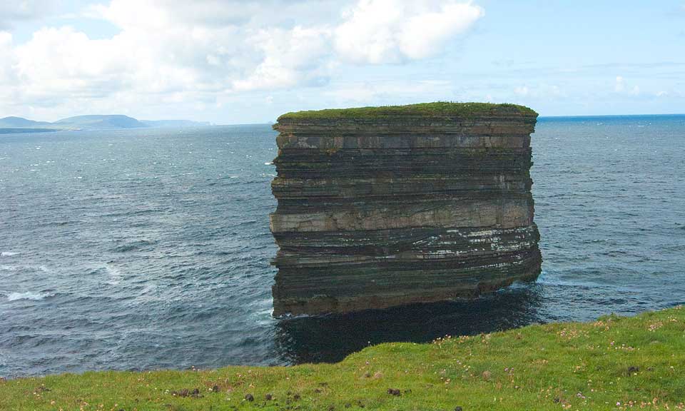
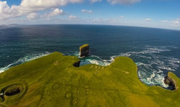
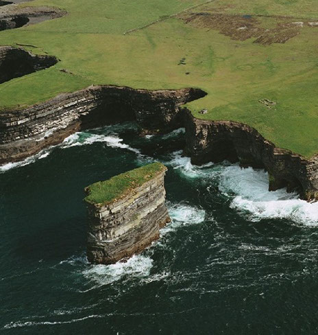 Standing impressively upwards of fifty metres in height and situated eighty metres off Downpatrick Head is an imposing perpendicular rock, the magnificent sea-pillar known as Dún Briste –‘the Broken Fort.’
The surface of the stack which is roughly forty metres round contains the ruins of what was probably a residence of some extent and the former land-bridge may once have been part of the fort’s fortification. The antiquarian, Thomas Joseph Westropp wrote that “Vergil’s lines on Sicily vividly describe Dunbriste - Haec loca, vi, quondam, et vasta convulse ruina, dissiluisse, ferunt, cum, protinus, utraque tellus una foret.”
There are several tales still told in the local folklore as to how and why the stack came to be separated from the mainland, and many of these tell of an ancient “ogre-pirate” who went by the name of Geodruisc or Deodruisc. In fact, in bygone days the pillar was formerly known as Dún Geodruisc or Dún Deodruisc. What follows is a flavour of some of these tales.
 One version tells that during the time of St.Patrick (fifth century) the aforementioned tyrant was living in his fort on the stack which was then attached to the mainland. Whenever Patrick ascended his altar (see piece on Downpatrick Head) to pray, the miscreant would appear and greatly annoy the Saint, so much so, that Patrick was, as the story goes ‘wearied out of patience with him,’ and as a result, one evening he prayed earnestly that God would place some barrier of separation between the nuisance and himself. According to this version of the tale, the fervent praying had the desired effect, for the very next morning the fort was found cut off from the headland and in the very place it lies today-hence the name of Dún Briste - ‘the Broken Doon or Fort.’ The story further informs us that ‘this was a complete excommunication, which placed the residence of the tyrant in such a position that he had no egress from it till he perished.’
 Another version informs us that once while Geodruisc was away on a plundering foray inland, he stole two cows belonging to a poor widow, the only things of value the unfortunate woman possessed. According to this tale, the widow afterwards followed the tyrant to his fort where she begged him return the animals to her, albeit without success. Seeing Geodruisc’s cruelty and insurmountable obstinacy for all that it truly was, the widow, in the custom of the place, bared her knees and knelt before his fort, where she then cursed him ‘from the heart out’ it is said. The consequence of the curse was that the fort split from the land leaving the dastardly robber at such a distance as it is to this present day, and as the tale tells ‘under such circumstances he perished’. A variant of this tale tells that it was St. Patrick who split the rock with his crozier leaving the tyrant and his savage dog alone on the stack without any form of sustenance. The dog eventually turned on his master and ate him, and it is from this tale that the vernacular saying ‘that’s where the dog ate the man’ originates.
 A third version would have us believe that one day Geodruisc, as he was accustomed to, sailed off to plunder by sea and on his return he discovered his fort separated forever from the mainland. Dejected, languid and melancholy, he turned his vessel around and sailed away never to return, leaving all his possessions behind. According to the lore, this particular version of the tale so impressed the local people with the supposition that there is a priceless treasure buried within the confines of Geodruisc’s Fort. See also the section on Kilcummin for Michael Mac Ruaidhri’s epic version of the tale.
In fact, it is documented in the Annals of the Four Masters that “under the year 1393” the narrow neck of land which joined the stack and the mainland the “Dunros and Tirawley” as it is referenced, was broken away by the sea during a hurricane-like gale. The Annals further inform us that several families were isolated on the stack as a result of the break, but were eventually rescued using “ships ropes.”
In 1981 several individuals were landed by helicopter on the summit of Dún-Briste. The party camped there overnight and the following day surveyed the surface during which they discovered the remains of a fine medieval dwelling, cultivation drills, walls, and a damaged quern stone (a stone used for grinding corn). Those who landed included Dr. Seamus Caulfield; his father, Padraig Caulfield; Professor Martin Downes; Father Declan Caulfield and the Archaeologist, Noel Dunne: R.T.E. television filmed the exercise which was later broadcast as a documentary.
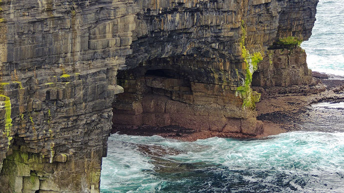
The majestic cliffs, including the sea-stack, were formed about 350 million years ago during the period known as the Lower Carboniferous Period, at a time in our history when temperatures were much higher than they are today.
A Statistical Survey of the County of Mayo, Dr. James Mac Parlan, 1802
 “The ruins of the building are clearly visible. Small flat stones, apparently from a quarry, lying in a confused position and in an uninterrupted heap, cover the whole of the south west side; and across in the direction from east to west runs a piece of a stone wall on which is observable a doorway or gateway. The original breadth of this passage cannot be well ascertained for the portion of the wall on the east side of it, which is only about three feet long and three feet high, does not retain the original form at this entrance. The portion to the east, by means of which a person can discern there was an entrance, is no more than four yards long and three feet high. It is impossible to know whether there is any cement or not in this ruined wall; even were the ruins of Saint Patrick’s Church, which lie on the head land, at the same distance, or let me say a far shorter distance from one, nothing could be observed but merely the stones of the walls, though there is some kind of sand to be seen among them when closely examined as will be hereafter observed. Within one hundred and thirty yards of the extremity of the neck of land a strong grouted wall seven feet broad and nine feet high runs across the point from sea to sea about sixty yards; the gateway is very narrow and strong.”
In 1838, thirty-six years after Mac Parlan visited, John O’ Donovan describes the aforementioned for the Ordnance Survey:
“Some of this strong grouted wall as yet remains. It appears not to have been seven feet broad; five feet would give a more exact idea of its breadth, for it was very little more. The cement, it appears, was made of coarse gravelly sand (apparently sea sand) and broken shells of various kinds. Though the wall has been pulled down on each side of the gateway its breadth can, how-ever, be well ascertained, which did not exceed three feet two inches. The extent of the wall, as far as is now traceable, is about eighty yards. Of it remain seven yards about four feet high and twenty nine yards about eight feet high in one place and five feet in another.”
Back to Mac Parlan:
“Everything indicates the rock and the building on it to have originally belonged to the mainland and the cross rampart to have been the fortification of the Castle. I can find no account, written or traditional, of the phenomenon. It certainly was a residence of extent, and a fortification of importance, and as neither its use, time of building, founder or separation from the mainland is any way recorded, it may well be supposed to be one of those ancient buildings which the invasions and rebellions of Ireland, that particularly of the first century of the Christian era, swallowed into eternal oblivion.”


Lorem ipsum dolor sit amet.2
Lorem ipsum dolor sit amet.3
Lorem ipsum dolor sit amet.5
Lorem ipsum dolor sit amet.6
Lorem ipsum dolor sit amet.7
Lorem ipsum dolor sit amet.8
Lorem ipsum dolor sit amet.9
Lorem ipsum dolor sit amet.10
Lorem ipsum dolor sit amet.11
Lorem ipsum dolor sit amet.12
Lorem ipsum dolor sit amet.13
<
>
2 - 11
View these photos in a gallery